GloFAS Methods
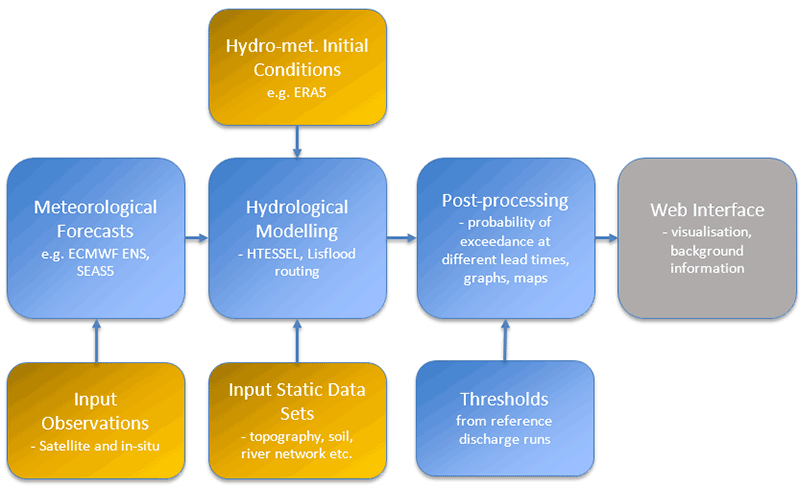
GloFAS modelling chain overview

Hydro-meteorological Initial conditions
GloFAS real-time initial states (atmosphere and land surface) are the conditions from which to start the ensemble discharge forecast. They are provided by a daily update of the atmosphere, land-surface and river states, every day for the past 5-day period based on a monitoring analysis of the latest observations. Because of the latency in the availability of real-time reanalysis data, day-1 forecasts from the ensemble control run of the ECMWF Integrated Forecast System (IFS) are used as fill-up when necessary for GloFAS forecasts initialisation.
ECMWF NWP forcing
GloFAS forecasts are produced using the latest ensemble of Numerical Weather Prediction (NWP) forecasts of the ECMWF IFS. Surface and sub-surface runoff outputs are routed with the Lisflood hydrological model over the GloFAS river network. The runoff is computed with the HTESSEL land-surface model of ECMWF. The medium- and extended-range ensemble runoff outputs are used for GloFAS 30-day, and the long-range SEAS5 ensemble runoff is used for GloFAS Seasonal.

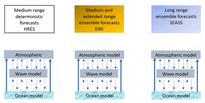
ECMWF forecasting system used in GloFAS
SEAS5 is the ensemble seasonal forecast of ECMWF (operational since 5 November 2017), and one of the seasonal forecast models of the Copernicus Climate Change Service. It consists of 51 members at ~36 km horizontal resolution. In GloFAS Seasonal, once a month SEAS5 runoff is converted into weekly-averaged streamflow with up to 4 months (16 weeks) lead time and published on the 10th of each month, in line with C3S SEAS5 forecasts publication date.
HTESSEL
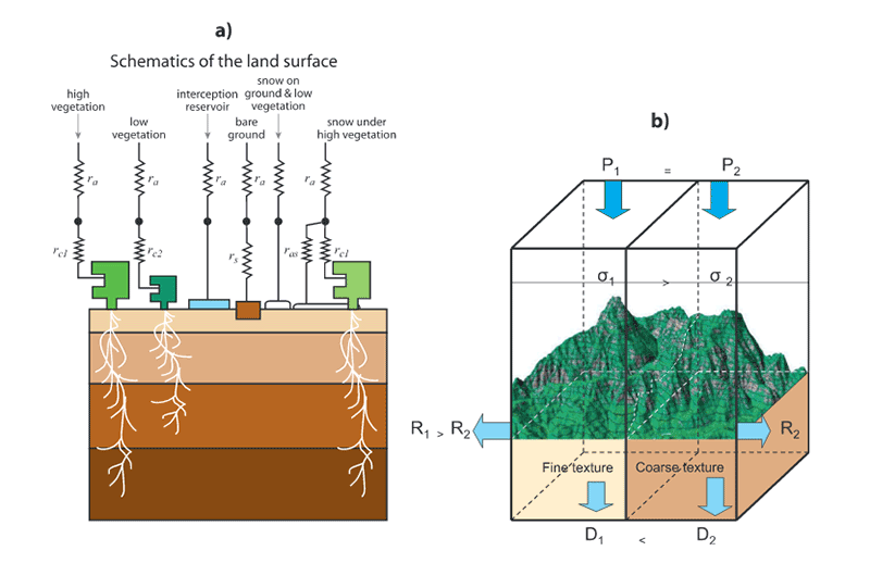
HTESSEL (Hydrology Tiled ECMWF Scheme for Surface Exchanges over Land) is the land surface scheme used by ECMWF in its IFS (Balsamo et al., 2009). HTESSEL computes the land surface response to atmospheric forcing, and estimates the surface water and energy fluxes and the temporal evolution of soil temperature, moisture content and snowpack conditions. Operational daily ensemble forecasts of surface and sub-surface runoff (soil to groundwater percolation) are extracted daily from the outputs of the ECMWF ENS and monthly from the outputs of SEAS5, then resampled to 0.1° resolution to be used as input to the river routing model of Lisflood.

Schematic representation of the structure of (a) TESSEL land-surface scheme and (b) spatial structure added in HTESSEL
Lisflood global
Lisflood (van der Knijff et al., 2010) is a GIS-based spatially distributed hydrological model, which includes a one-dimensional channel routing model. The Lisflood model is currently running within the European Flood Awareness System (EFAS) on an operational basis covering the whole of Europe on a 5 km grid.
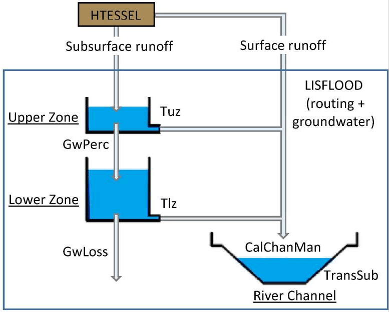
In the context of global flood modelling in GloFAS, the transformation from precipitation to surface and sub-surface runoff is done by HTESSEL, with Lisflood global being set up to simulate the groundwater and routing processes. Surface runoff is routed via overland flow to the outlet of each cell; subsurface storage and transport are modelled using two linear reservoirs. Lisflood routing parameters were calibrated against observed discharge time series at 1287 stations across the world for better accounting of the variability in the hydrological processes (Hirpa et al., 2018). See Lisflood calibrations pages.

Schematic of the Lisflood hydrological model configuration used in GloFAS
GloFAS reference discharge runs
GloFAS forecast reruns. They are forecast simulations performed for a set of past dates, based on a configuration as close as possible to the operational setting. They can be used to analyse GloFAS skill systematically over a long period or define lead-time dependant percentile thresholds (e.g. GloFAS Seasonal).
GloFAS discharge thresholds. They are sets of maps against which to compare GloFAS forecasts to generate flood awareness forecast or river flow anomaly maps. For GloFAS 30-day, they are based on the GloFAS forecasts hydrological reanalysis. For GloFAS Seasonal, they are based on GloFAS Seasonal forecast reruns, so that possible drifts in the forecast due to longer lead time are accounted for.
Please refer to the GloFAS wiki for the exact configuration of different GloFAS systems.
Version numbering system for the GloFAS cycles
- The first number relates to major upgrades that involve changes to the hydrological modelling chain (e.g. rainfall-runoff and routing)
- The second number relates to any other change in the system’s configuration that have an impact on the discharge (e.g. change of the reference climatology, change of the forecast reruns or an upgrade of the real-time ECMWF IFS data input)
For clarity and for their development cycles to be as flexible as possible, GloFAS forecasts and GloFAS Seasonal are considered as two independent systems with their own numbering, but following the same convention.
Each version comprises data associated with
- the operational real-time forecasts
- the hydrological reanalysis
- the discharge forecast reruns
- the discharge thresholds
Please refer to the GloFAS wiki to know the latest version currently in operation for GloFAS forecasts and GloFAS Seasonal.
