Implemented by the European Commission as part of the Copernicus Programme
The 2nd CEMS Global Flood Forecasting and Monitoring Meeting was held online on 8 and 9 February, from 13 to 17 UTC. More than 300 participants attended the event over the two days.
The meeting was highly interactive, with presentations on the latest developments of the Global Flood Awareness System (GloFAS), of the Global Flood Monitoring (GFM), and of the GloFAS and GFM data access and documentation. Keynotes and IGNITE talks provided the opportunity for 16 representatives of related initiatives to introduce their developments, use cases, and experiences using GloFAS and/or GFM data. A panel discussion was organized to share views on the actions required to support the United Nations #EarlyWarning4All initiative.
This page presents a short summary of the event. The presentations (in pdf format) can be downloaded as single files using the links provided throughout the text, or they can be downloaded in bulk as zipped folder using the link at the bottom of the page: section Files (52.3 MB).
 Two sessions were dedicated to CEMS GloFAS products and data, and the system’s contribution to flood early warnings at the global scale.
The growing number of registered users demonstrates an increasing interest and confidence in GloFAS usefulness. The precious feedback received from the users contributes to setting the priorities for future developments.
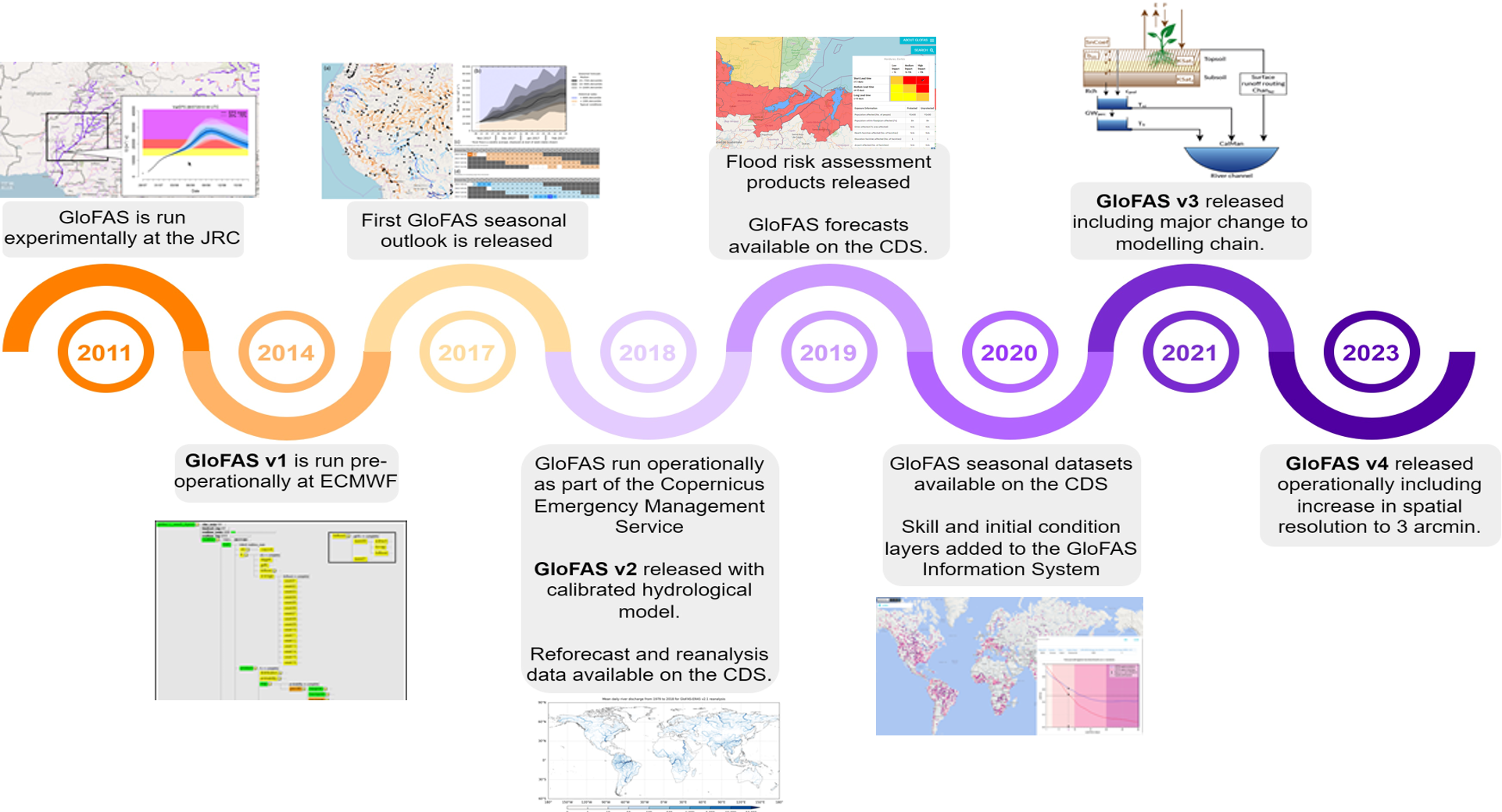
The presentations also covered the upcoming (in 2023) operational release of GloFAS v4.0. The major changes to the system will include:
| A short intro to the Global Flood Awareness System (GloFAS) presented by Christel Prudhomme (CEMS Hydrological Forecast Centre-Computation, ECMWF) |
| What’s new in GloFAS v4.0? presented by Stefania Grimaldi (EC JRC) |
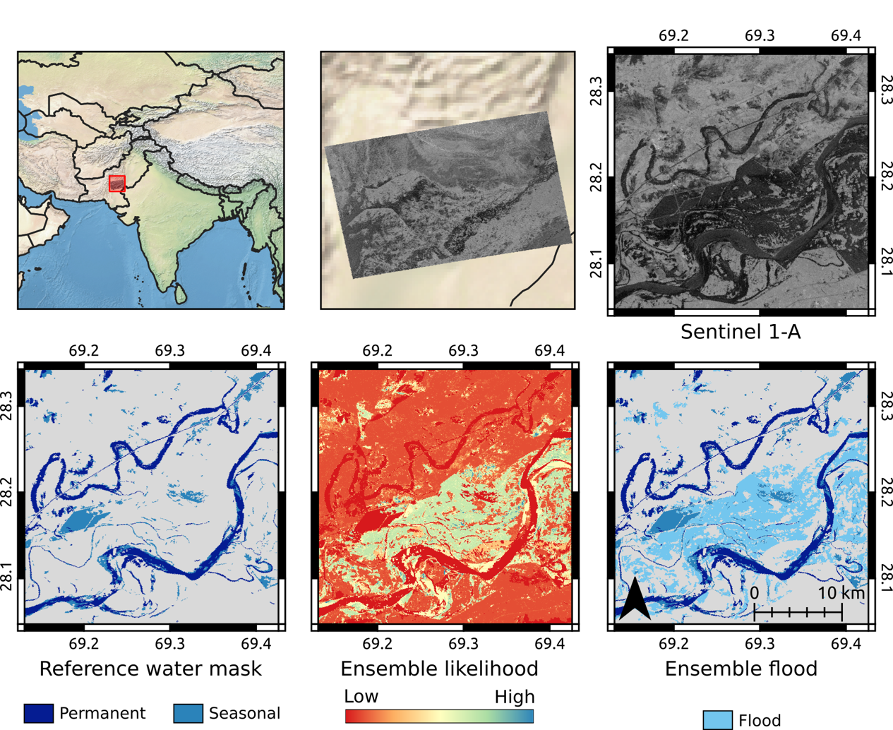
Two sessions were then dedicated to CEMS GFM. These sessions showcased the significant progress achieved in the processing of the Copernicus Sentinel-1 imagery archive and GFM's accuracy and reliability. Furthermore, attendees received insights into the upcoming GFM updates and improvements, highlighting the ongoing commitment to regularly improving the tool’s performance.
The major innovations introduced with GFM v2.0.0, which was released operationally on January 2nd 2023, include:
The GFM archive consists of more than 1.4 million automatically analysed Copernicus Sentinel-1 images, from its commissioning in 2015 to the present date. However, the archive does not cover all areas of the globe with the same revisit time, as areas in Europe, Central Asia and Western Americas are covered with a higher frequency than the rest of the globe because of Sentinel-1's orbit.
| A detailed look at the Global Flood Monitoring (GFM) product presented by Christian Krullikowski (CEMS Global Flood Monitoring Centre, German Aerospace Center) |
| The new GFM archive presented by Bernhard Bauer-Marschallinger (CEMS Global Flood Monitoring Centre,TU Vienna) |
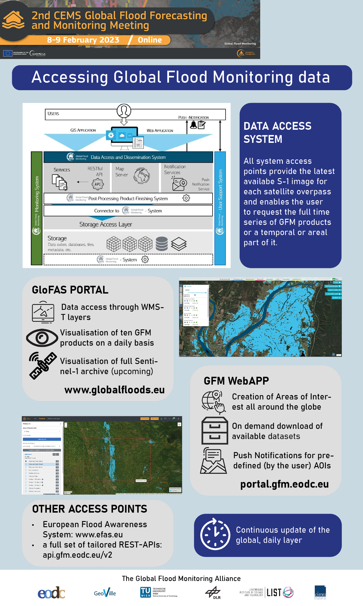
 The event included detailed demonstrations about how to access GloFAS and GFM data.
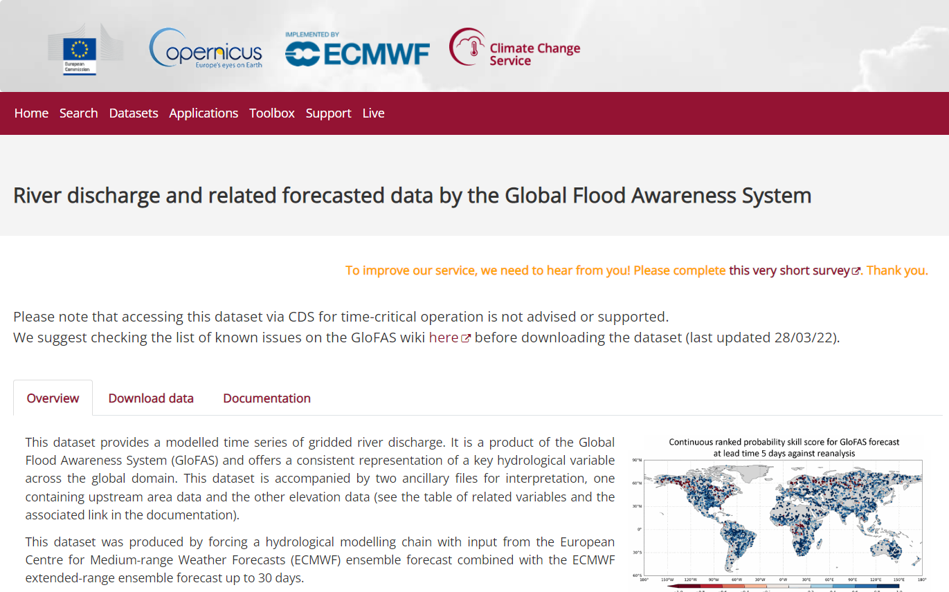
GloFAS data can be accessed using the Climate Data Store (CDS). The demonstration provided an overview of the structure of the CDS and of the GloFAS catalogue entries. An online processing facility (CDS Toolbox) allows the users to tailor their data request prior to download; a suite of online training material has been designed to support the users' needs.
The GFM Quick Start Guide explains how to access GFM data. Users can designed their area(s) of interest in order to download the relevant GFM data, moreover, users can receive notifications on GFM-detecetd floods for their area(s) of interest.
Detailed documentation about GloFAS and GFM is available from the Forecast Wiki, and from the Moitoring Wiki, respectively. The GloFAS User Guide was published just the day before the event to complement the the techincal infromation of Forecast Wiki. Specifically, the GloFAS User Guide provides information on GloFAS products and services for both the first-time users and those who want to learn more about available services and data.
| Using the C3S Climate Data Store to access GloFAS data presented by Edward Comyn-Platt (CEMS Hydrological Forecast Centre Computation, ECMWF) |
| The new GloFAS User Guide presented by Nina Bosshard (CEMS Hydrological Forecast Centre Analytics and Dissemination, SMHI) |
| Accessing and using GFM data presented by Michaela Seewald (CEMS Global Flood Monitoring Centre, GeoVille) |
During the event, 3 keynotes and 13 ignite talks describing use cases for GloFAS and/or GFM data were presented.
The first keynote, "Creating flood event based informaton merging GloFAS, GFM, and media sources" presented the ongoing work of the EC JRC for the set-up of an operational single entry point for the collection of harmonized information of flood events at the global scale. Information from GloFAS, GFM, and media sources are collected before, during, and after the event to provide semi-automated, harmonized stream of information to EU Emergency Response Coordination Centre and GDACS (and possibly other humanitarian organizations). The second keynote "ARC flood insurance product which relies on GLOFAS" discussed the use of GLOFAS forecasts within the African Risk Capacity and JBA probabilistic approach to support the delivery of a practical and customizable flood parametric insurance product. The third keynote "Impact-based multi-hazard forecasting in Africa" presented the inclusion of GloFAS forecasts into an African Multi-Hazard Early Warning and Action System (AMHEWAS) for Disaster Risk Reduction with the puropose to provide impact-based warnings in the bi-weekly Continental Watch bulletin of the African Union.
The 13 ignite talks showcased a range of applciation including improving flood early warning systems, flood depth estimation, multi-reservoir system operation, flood frequency analysis, compound flood modelling/forecasting, and the use of social media to complement GloFAS and GFM. This diverse range of applications demonstrates the versatility and value of GloFAS and GFM data in addressing different flood-related challenges. The use cases presented also highlighted the potential of these tools to support decision-making and response efforts for floods at both national and international levels.The presentations of the keynotes (identified by the symbol *) and of the ignite talks are available for download below (this page list the name of the presenters, the complete authors' list is reported in the attached documents).
A Panel Discussion was also held during the workshop with input from Stefan Uhlenbrook (WMO), Abdou Ali (AGRHYMET), and Monica Turner (UN OCH). The three experts on the panel discussed frameworks and initiatives relevant to the United Nations #EarlyWarning4All initiative. Examples are the development of global flood forecasting and early warning systems globally, such as the Union civil protection mechanism, floods directive, and the Sendai framework for disaster risk reduction.
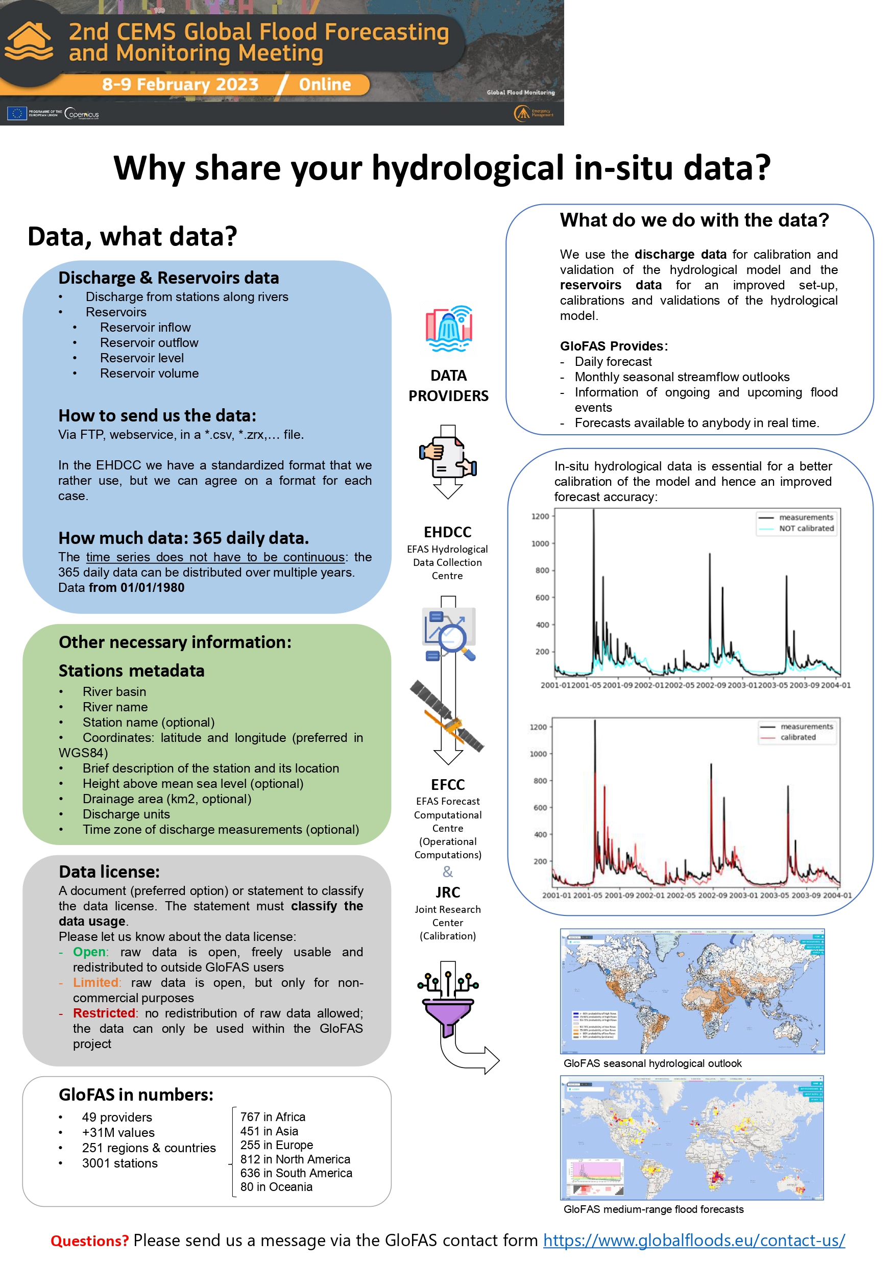
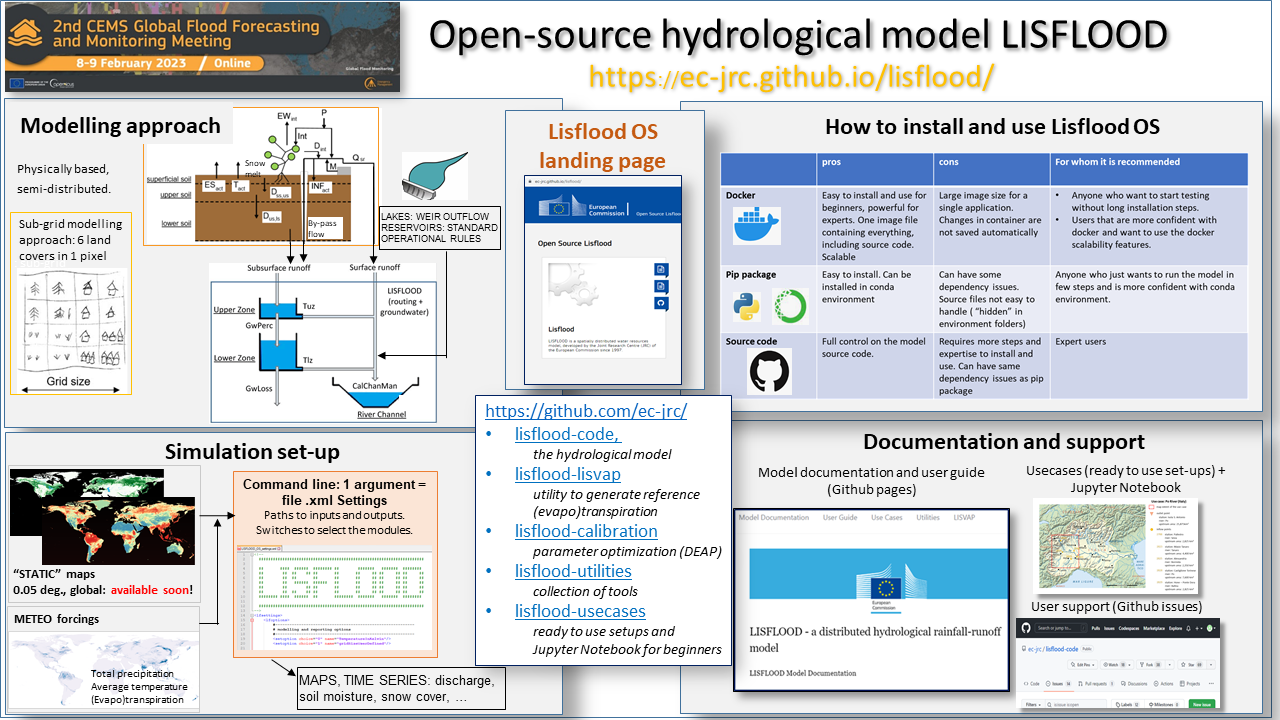
The last section of both the days of the event was designed as a highly interactive session. Specifically, the participants could explore a virtual conference space (the selected platform was Gather.Town) to join a virtual poster exhibition and virtual booths. This virtual conference space allowed the participants to directly connect with representative of the CEMS GloFAS and GFM, the presenters of the keynotes and of the ignite talks, and all the other attendees. The poster exhibition included the ignite talks (only the full presentation is available in this page), and additonal in-depth techincal descriptions of CEMS activities such as (i) access systems for the provision of GFM data; (ii) the collection of hydrological in-situ data to support GloFAS; (iii) the development and maintainance of open source hydrological model LISFLOOD for the computation of GloFAS forecasts.
 |
 |
||
| Presented by Michaela Seewald (CEMS Global Flood Monitoring Centre, GeoVille) | Presented by Alejandro Serratosa (CEMS Hydrological Data Collection Centre, GHENOVA Digital) |
 |
|
| Presented by Carlo Russo and Stefania Grimaldi (EC JRC) |