GloFAS v3.4 Release and GloFAS v4.0 hydrological reanalysis dataset Announcement
The latest version of the Global Flood Awareness System (GloFAS) version 3.4 is currently being implemented. Furthermore, the GloFAS v4.0 hydrological reanalysis dataset, which is the new historic river flow dataset at 0.05 degrees resolution, has been released in anticipation of the planned major system upgrade (GloFAS v4.0).
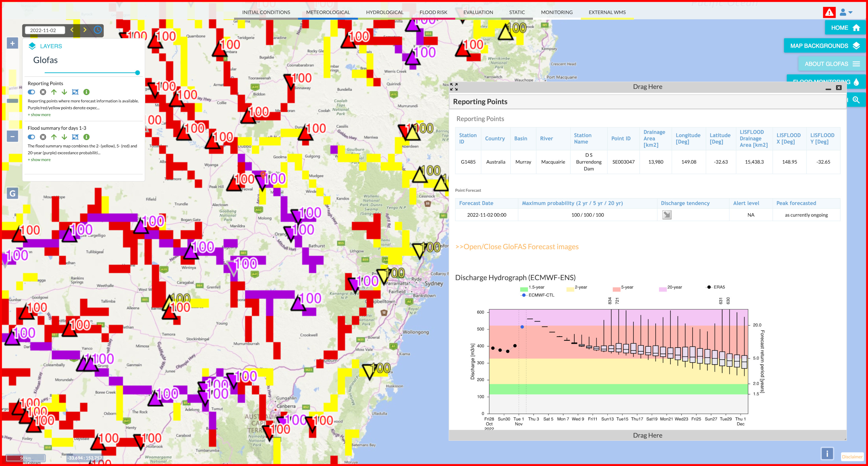
GloFAS version 3.4 introduces some important enhancements to the web products, including methodological, visual, and technical changes. The changes aim to aid user experience when interpreting the forecasts on the GloFAS map viewer. Here is a summary of the main changes:
- Upgrades to hydrological and static layers, including: ‘Flood summary maps’ coloured according to the probabilities of exceeding 2-(yellow), 5-(red), and 20-(purple) return period thresholds, a new ‘Flood summary for days 1-30’ layer, 5- and 20-year return period exceedance maps, and homogenisation of ‘Rapid flood assessment’ layer to align with how flood severity is defined in the reporting points. The ‘LISFLOOD Drainage Area’ vector layer replaces the ‘Upstream Area’ layer.
- Upgrades to the Reporting Points products, including: improvements to the dynamic reporting point algorithm, forecast tendency and peak date algorithms are now defined according to the ensemble median, indication of peak timings for forecasted floods, reporting points now only indicate flood severity categories, improvements to the discharge hydrographs, and more.
- Improved map viewer features, including: ‘Multi-tab’ feature allowing users to view several queryable products in a single window, and new functionalities of the pop-out windows to aid user experience.
For users to familiarise themselves with the new products, GloFAS v3.4 will be shown on the GloFAS Stage platform: https://stage.globalfloods.eu/glofas-forecasting/ from 16 November 2022 for about a three-week period, until the operational release of the products on the main GloFAS website, expected early December 2022.
To access the GloFAS stage website, visit https://stage.globalfloods.eu/accounts/signup/ to create an account.
For more technical information on the release of GloFAS v3.4 please see the dedicated wiki page following the date of release.
The GloFAS v4.0 hydrological reanalysis dataset was produced using the planned major upgrade GloFAS v4.0. GloFAS v4.0 is expected to be released operationally in 2023 and it will introduce a number of major changes to the system, including:
- higher spatial resolution. GloFAS v4.0 has 0.05 degrees resolution (~5km), as opposed to all the previous GloFAS versions having 0.1 degrees resolution (~10km).
- an entirely new set of 0.05 degrees resolution input maps.
- major improvements to the open-source hydrological model LISFLOOD.
- a new calibration at 1996 in-situ gauging stations.
The GloFAS v4.0 hydrological reanalysis provides daily maps of discharge (in m3/s) with quasi global (+90,-60,-180,180) extent at 0.05 degree (~5km) grid resolution from 01/01/1980 to 31/07/2022. The release of this dataset before the operational release of GloFAS v4.0 is the first major step towards this upgrade. The new historic river flow dataset is publicly available on the Climate Data Store of the Copernicus Climate Change Service, a detailed description can be found in the dedicated wiki page.
Questions and feedback can be submitted via the contact form: https://www.globalfloods.eu/contact-us/.
By Stefania Grimaldi Nov. 16, 2022, 4:39 p.m.